Planimetries
archaeological II Returning to the subject in the This post will try to get a mapping methods digitized from a paper-based documents, such as a sheet of graph paper with a drawing of what we want. A fairly common case, of course.
The simplest procedure is to digitize or scan in tiff, jpg, png, etc through a document scanner and import the vector drawing program of your choice (inkscape , Xara Xtrem , Openoffice Draw ...). This step can be done to hair, ie without taking into account the scale and the north, so that the scanned drawing is incorporated into a layer above and create another block the layer containing the draft so we can draw comfort. Later we can draw directly with the tools of the points, lines, polygons, etc. In the end, put a scale and north, and presto: we have a more or less decent.
If the aim is to obtain a copy and some more, do not really need to go much further in the creation of our mapping. But sometimes the mapping is a type of documentation base from which we can obtain additional information or consult other information such as calculating areas such sectors or areas of excavation, or measure distances between elements of interest, or even serve as a reference for where to place new information that can be analyzed, as might be the distribution of materials by type, etc. In this case it is useful, at least, the mapping is at a specific scale that can be managed easily, ie not at 1:10 and 1:45,286 for example. Clearly, a 1:1 ratio is ideal.
Most vector programs can handle this kind of scales, some with specific tools, as is the case in Xara Xtrem , which allows state specifically what scale we are working. Inkscape, for its part, the document properties can be established units such as meters or centimeters and if we disable the option to show the edges of the page, get an unlimited area to represent our mapping. It may be useful also to establish a grid or grid that corresponds to the field is set, which can be used to set the draft drawing to scale.
A step further will be thinking
As some of you reading this, if we work with scales, to obtain measurements of our planes and even represent other phenomena about them, we question the use of conventional vector drawing programs and migrate other programs, specifically made or significant CAD. We have in this area many open-source software or free that can help us. Qgis propose , Openjump , gvSig , QCad , MapMaker ...If we continue with the assumption that our plant is the source document in the field drawn on graph paper and of course to scale, and have already scanned in tif, jpg, etc, the first and essential step is to establish the scale and coordinates so that our GIS or CAD software to understand, that is, we georeference the drawing. Through this process, we will give the image coordinates that correspond to the reality it represents. Generally
georeferencing As its name implies, is used to establish their geographical coordinates on maps in GIS and mapping environments. However, considering our excavation as a coordinate system relative to an origin (0,0)-point-zero, any plant drawn to represent all or part of excavation can be georeferenced with respect to this particular coordinate system.
In reality there are many methods to make georeferencing. In quantum Gis georeference images is extremely simple, through one of the supplements ( Georeferencer ) which can be obtained from within the program interface. Thus, we simply indicate each of the four points with known coordinates needed to generate an additional file (file world) that contains information about the coordinates of the image.

View georeferencing of an image in Quantum GIS.
There is also a specific program very simple to use to geo-reference images based on the libraries called MapWindow Georeferencing Tool, which requires knowing the coordinates of at least three points on the image to generate the world. Or if you want to georeference in gvSig, we can follow the following video A. Which explains step Díez step.
QCad can also insert images that will serve as a background on which to draw the plans, and we MapMaker georeferencing images in different ways. To work with qcad consult and create a coordinate system on , quite in the vein of what we are explaining here. Both
qcad as with other programs, it is often necessary and / or desirable for the image is properly oriented to the north or into the Y axis of the local reference system, since avoiding forced rotations that reduce image quality or hindering the proper functioning, so that after scanning the image advise treating to fit these requirements.
Once georeferenced, the image can be loaded in each of the programs as a layer on which we are able to directly digitize the plans of the excavation, retaining at all times the reference coordinates.
more in future deliveries.
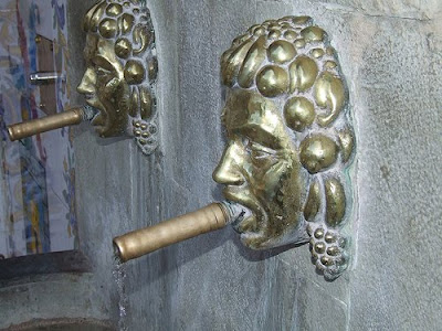
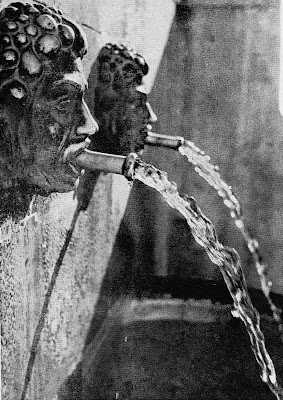 In every town there is a landmark as a meeting point in Onil no doubt this is "the Plaça Xorro." It is a source of two pipes located on the side of the Plaza Staff at the foot of the street Nostre Senyor Robat and uniqueness is that its pipes are two tubes coming out of both sides of golden bronze.
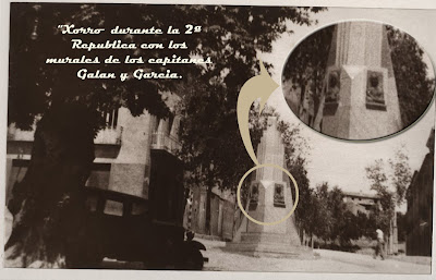
 The third source would be the end of the twenties and lasted the least, his situation was

.jpg)
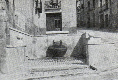 Years later, namely in 1985, was restored, tiling all sides of the square with typical Valencian tile murals of coats of Spain, Onil, Valencia and Alicante Provincial Council, with an approximate cost of 500,000 pesetas, to be opened restoring the Constitution Day of the year (12/06/1985)